|

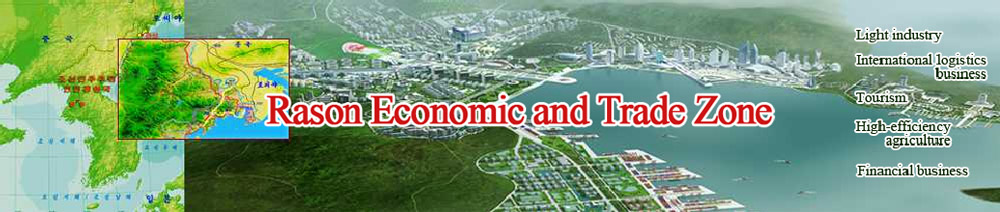
Investment environment in Rason Economic and Trade Zone
Nature and geography
Natural resources and infrastructures
Legal groundwork and economy
Finance, education and culture
Investment Projects
Projects for Development of Industrial Parks
Projects for Development of Tourist Destinations
Investment Projects for Local Industries
Investment Items
Investment Policy
Tax Policy
Procedures of Enterprise Establishment
Management Committee of Rason Economic and Trade Zone |
Investment environment in Rason Economic and Trade Zone
>> Nature and geography
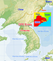 The Rason Economic and Trade Zone (hereinafter called Zone) is located on the lower reaches of the Tuman River in the northeastern part of the Democratic People’s Republic of Korea. It is situated between Lat. 42° 08′ N and 42° 38′ N and between Long. 130° 07′ E and 130° 42′ E. The Rason Economic and Trade Zone (hereinafter called Zone) is located on the lower reaches of the Tuman River in the northeastern part of the Democratic People’s Republic of Korea. It is situated between Lat. 42° 08′ N and 42° 38′ N and between Long. 130° 07′ E and 130° 42′ E.

It is bounded on the north by Hunchun City, Jilin Province of China and Khassan of Russia across the Tuman River.
Rason Municipality has an administrative area of 890 square kilometres, of which the Zone covers 470 square kilometres, and the area for possible development with an incline of less than 20 degrees 230 square kilometres.
The Zone is divided into two districts, Rajin and Sonbong: they are port cities with clean environment. They are recognized as earthquake-free districts with 80% of mountainous areas and 120 km of coastline.
As it belongs to the sub-temperate zone in the northern hemisphere, the Zone has a typical oceanic climate.
Its average annual temperature is 9℃: the average temperature in January is -8.8℃ and that in August, 20℃.
Its mean annual precipitation is 775 mm. The drying season is from December to March and the rainy season is from June to August.
Its annual sunshine duration is 2 348 hours.
The population in the Zone is over 198 000. The proportion of males to females is 55 to 45, and those aged from 1 to 15 account for 30%, those aged from 16 to 59, 62% and those aged over 60, 8%.
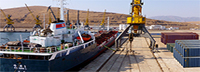
Those at working age amount to over 103 000. It is planned to increase the population in the Zone to a million.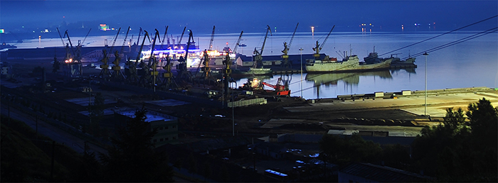 The Zone has Rajin Port with an annual turnover of 6 million tons of various bulk cargoes and containers, Sonbong Port with an annual turnover of 3 million tons of petroleum and bulk cargoes and Ungsang Port with an annual turnover of 0.5 million ton of timber. The Zone has Rajin Port with an annual turnover of 6 million tons of various bulk cargoes and containers, Sonbong Port with an annual turnover of 3 million tons of petroleum and bulk cargoes and Ungsang Port with an annual turnover of 0.5 million ton of timber.
These three ports are not influenced by seasonal changes.
It is expected that the annual turnover of the three ports will increase to 125 million tons in the future.
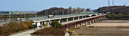
The Zone has the 50-km-long Rajin-Tumangang Railway which is linked with the Siberian railway of Russia through Khassan and the 150-km-long Rajin-Namyang railway which is linked with Tumen in Jilin Province of China.
In 2013 the Rajin-Tumangang railway was updated into a broad-gauge railway according to the agreement between the DPRK and Russian governments.
In the Zone there are the 50-km-long Rajin-Wonjong Road, which is linked with China through the bridge between Wonjong of the DPRK and Quanhe of China, and the 45-km-long Rajin-Tumangang Road, which is linked with Russia through the bridge between the Tumangang of the DPRK and Khassan of Russia.
According to the general plan of the DPRK-China joint development the Rajin-Wonjong Road was renovated in 2012 so as to increase its annual freight traffic to six million tons.
In the Zone there is the Anju Heliport where four helicopters can take off and land at the same time. It is planned to build an international airport in Samhae-ri, Chongam District, Chongjin City, North Hamgyong Province.
|